Geographic Environment
Mount Tai runs through the central part of Shandong Province, within the territory of Tai’an City, between Tai’an, Jinan and Laiwu.
In front of Mount Tai is Qufu, the hometown of Confucius, and back to Jinan city, the city of Quancheng. Mount Taishan rises in the east of the North China Plain and is above the Qilu Plain. It faces the sea in the East and the Yellow River in the west. In the south, there are Wen, Click Here For More. Sihuang and Huaihe rivers. Its East-West length is about 200 kilometers. Its north-south width is about 50 kilometers. Its main mountain range and offsets cover more than ten surrounding counties. It covers an area of 426 square kilometers and its main peak, Yuhuangding, is 1,545 meters above sea level.Click Here For More.
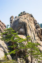
Mount Tai is the largest mountain range in the hills of Shandong Province. The stratum is the typical basement and caprock structure area of North China Platform. The southern part of the plateau rises greatly, and the caprock is weathered away, revealing a large area of basement- Mount Tai Complex, i.e. the stratum of Mount Tai Group in the Archaeozoic Era. Its absolute age is about 2.5 billion years, and it is one of the oldest strata in China. In the north, the rise is small, and the typical Paleozoic strata developed on the North China platform are preserved in the caprock.